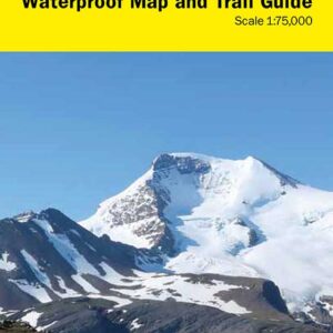
Description
The newest edition of the Summits & Icefields series has arrived!
This is a marked route map and mini-guide for skiers and climbers traveling to this internationally-renowned destination.

$19.95
by Mark Klassen, TJ Neault, Chic Scott
Some features include:
Waterproof and tear resistant Yupo paper, dimensions 24 X 32
1:50,000 scale, with 20 m contours
Up to date glaciation dataset
The map extends from Mt Patterson in the north to Cathedral Mtn in the south, and from Collie Creek and Amiskwi River in the west to Mt Hector in the east
Marked route lines of all corresponding trips mentioned in the Summits and Icefields Volume 1 ski touring guidebook
On the reverse side is the mini-guide
A 1:20,000 scale map of the Balfour High Col area
13 colour photographs with marked route lines
Mini route descriptions and route plans
Out of stock
The newest edition of the Summits & Icefields series has arrived!
This is a marked route map and mini-guide for skiers and climbers traveling to this internationally-renowned destination.
Input your search keywords and press Enter.